
I have received numerous e-mails and phone calls seeking help with using MARPLOT to obtain RMP OCA Populations so that this year RMP update will use 2010 Census Data. As I wrote last year, LANDVIEW is no longer a viable option and EPA has instructed us to use “other sources” specifically mentioning MARPLOT as an option. This article is meant for SAFTENG MEMBERS needing assistance with using MARPLOT to obtain their census data for their OCA’s. PLEASE NOTE: this information was obtained from FREE sources on the internet and from EPA; a little bit of time and work will provide this information, therefore you do not need to join SAFTENG for any of this information. I have just compiled, researched, and provided it in a timely fashion for those in need of assistance and that is why I have made it MEMBERS ONLY.
Note that if you download the new population files at this time, MARPLOT will ONLY use the 2010 data for “get population” functions where the radius is less than 25 miles (otherwise it uses different population levels, such as Tracts, which still have 2000 data).
Existing MARPLOT Users: How to Get the New Population Data
If you’ve used the “Get Population” feature, then you already have one or more 2000 Census, state-level populations files on your computer. (You may have also downloaded population files using the Download Manager.) These files can be updated to the new 2010 census data by following these instructions:
- Start MARPLOT.
- Under the Help menu, select the “Check for Updates” option.
- MARPLOT will display a list of base map layers (primarily census block data) that are out of date and should be updated. Note that this list is specific to your version of MARPLOT; the program looks at the files you’ve already downloaded and only looks for updates for those files. Click Start Download.
- Once the download is complete, exit MARPLOT.
- Browse to the location of your MARPLOT program folder (e.g., C:\Program Files\MARPLOT).
- Double-click on the “reindex.bat” file, which will allow MARPLOT to recognize the newly-downloaded population files.
- You can then restart MARPLOT, and the new population data should be available.
New MARPLOT Users: How to Get the New Population Data
If you are a brand new MARPLOT user, you do not have to update/reindex your population files at this time.
When you download census block population files (either with the Get Population feature or using the Download Manager), they will automatically be the 2010 census files. However, if you download other census levels (e.g., Block Groups, Counties, and Tracts) be aware that those files will still be 2000 data, and you may need to update those to 2010 data at a later date when they become available.
If you have questions or problems, please contact CAMEO User Support at (703) 227-7650 or [email protected].
Downloading Maps
NOTE: If you’d like to have a map of your OCA area(s)… Census 2000 MARPLOT Maps are available at NO COST. Contact the RMP Reporting Center at (703) 227-7650 or via e-mail at [email protected], to obtain maps for your area.
MAC USERS:
They do have a MAC version now; however, if you are running Lion OS or later the MARPLOT 3.3.3.1 installer provided above will NOT work on a Macintosh with a Lion (10.7), Mountain Lion (10.8), or Mavericks (10.9) operating system, because the installer is a PowerPC application (no longer supported by MAC). To install MARPLOT on a computer running Lion or later, contact the CAMEO Suite Specialist (at [email protected]) for assistance. I have done this and once I hear back from them, I will post here. PLEASE SEE the bottom of this posting to see the response from NOAA regarding this issue with MACs.
LandView® as a database management system – sometimes referred to as a DBMS and MARPLOT as a map viewer are two stand-alone applications that communicate with each other. For one or more records “found” in LandView, MARPLOT can display both their physical location and their location in relationship to other mapped objects such as roads, rivers or jurisdictional boundaries. Conversely, LandView will display the informational attributes associated with a found set of MARPLOT map objects. Thus, the physical location of an object becomes an important part of its informational data. This is the fundamental concept underlying a Geographic Information System or GIS.
Pathways between the two applications are documented in the LandView Help files, Go to Map, Show on Map and MARPLOT Sharing Menus. Additionally, MARPLOT has its own set of Help screens, available from the MARPLOT MenuBar. Power users of MARPLOT may wish to access the MARPLOT Technical Documentation.
MARPLOT is a user-friendly application that has supported all previous versions of LandView and continues as the mapping application associated with LandView 6. Originally, MARPLOT was developed as part of the suite of programs associated with CAMEO®, an emergency planning and response software concerned with protecting the community from accidental chemical releases. These applications, CAMEO®, MARPLOT and the ALOHA plume modeling program, are a joint work product of the National Oceanic and Atmospheric Administration (NOAA), the Environmental Protection Agency (USEPA) and the Census Bureau.
The LandView 5 release was supported by MARPLOT Version 3.3. A newer release, MARPLOT 3.3.1, supports LandView 6 – this update addresses the manner in which LandView finds MARPLOT maps when a user selects one of several alternate LandView installation procedures. See both Network Installation of LandView and Alternate Installation Procedures.
MARPLOT supports the creation of user-entered map data. Again, the user is referred to both the MARPLOT Help files and MARPLOT Technical Documentation. Included as part of LandView installation is a MARPLOT utility, Shape to MIE (shp2mie), which provides additional support to MARPLOT. Shp2mie creates MARPLOT Import Files from ESRI shapefiles. Most GIS data that can be converted to a shapefile can be imported into MARPLOT.
What data does LandView 6 provide and will it be updated with 2010 Census data?
Released in January 2004, LandView 6 contains Census 2000 data and is the most current version available. LandView 6 will not be updated with 2010 Census data. Currently, the Census Bureau is working on a similar product that will incorporate updated data. This product is in early planning stages; therefore, a completion date is not available. While this new product is underway, we recommend that users download the EPA’s free MARPLOT tool containing 2010 Census data. Instructions for use and a download link are available at www.epa.gov/oem/contact/cameo/marplot.htm.
The U.S. Census Bureau, the Environmental Protection Agency (EPA), and the U.S. Geological Survey (USGS) developed LandView. It is a Windows based application and contains both a mapping and a database component. The mapping component, MARPLOT, allows you to create simple thematic maps of Census data, locate street addresses using TIGER/Line data and generate maps of EPA regulated sites and places from the USGS Geographic Names Information System (GNIS). The database component allows you to browse and query Census Bureau, EPA, and USGS databases. In addition, LandView has a population estimator that will calculate the population and housing units within a specified radius around a focal point (set on the map) or from coordinates entered on the population estimator form.
For technical assistance or to order LandView 6, you can contact the Geography Division at the Census Bureau by phone at 301-763-1128 or by email at [email protected].
www.epa.gov/oem/contact/cameo/marplot.htm
On Apr 29, 2014, at 2:13 PM, Brianne Connolly <[email protected]>; wrote:
Bryan
The latest version of MARPLOT (v. 4.2.4) is a Windows-only application. However, there are two options for Macintosh users:
If you have an Intel-based Mac, you can run MARPLOT 4.2.4 using Boot Camp or virtualization software that allows you to run Windows on your Macintosh.
You can run an older version of MARPLOT (v. 3.3.3.1). However, be aware that it uses older maps and doesn’t have many of the new features added to the MARPLOT 4.x series.
A sample of the MARPLOT 4 series is shown first; a MARPLOT 3 series sample is shown second.
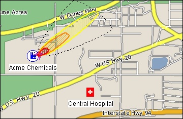 |
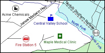 |
If you wish to use the older MARPLOT program on a Mac running Lion (10.7), Mountain Lion (10.8) or Mavericks (10.9), you’ll need to install the program by hand. (Unfortunately, the installer posted on the website is a PowerPC application, which will no longer run on the new operating systems.) If you’d like the program files and instructions for the old MARPLOT, please email me.
We are in the process of developing a new MARPLOT 5 series, which will work on Macs and PCs. However, there is no release date for this product yet.
Regards,
Brianne Connolly
—
Brianne Connolly
NOAA Office of Response and Restoration
Emergency Response Division
[email protected]
On Apr 29, 2014, at 2:46 PM, Brianne Connolly <[email protected]>; wrote:
Bryan
To install MARPLOT 3.3.3.1 on a Mac running Lion, Mountain Lion, or Mavericks:
Attached is a zip file for MARPLOT 3.3.3.1. Uncompress it and then place the resulting folder in your Macintosh Applications folder.
To install the MARPLOT font (for symbol objects), double-click on the file “MARPLOT Fonts” in the MARPLOT folder. The system should offer to install the font at that point.
Depending on your Gatekeeper settings, you may find that the program will not open because it is produced by an “unidentified developer”. If you get an error message to that effect, you can tell your Mac to make a special exception to the security settings for just this program by (a) browsing to the MARPLOT application file, (b) control-clicking (or right-clicking) on the MARPLOT application file, (c) choosing Open from the right-click menu that appears, and (d) clicking on Open on the dialog box that appears asking if you are sure that you want to open this application. Once you have given the computer permission to open this file from an “unidentified developer” it will remember that for the future, so you need only perform these special steps once for this program. (If you have your Gatekeeper security settings configured to allow programs from anywhere, you won’t need to perform these steps at all.)
The MARPLOT Folder has a test map (for Prince William county) included in the MARPLOT folder. To obtain maps for other counties (from the 2000 Census), contact the RMP Reporting Center at (703) 227-7650 or via e-mail at [email protected].
Regards,
Brianne